
When I worked for the power company early in my career, my boss was a guy named Bob. He was brilliant, innovative, creative—and totally paranoid.
Bob was convinced that his colleagues, management, and the union were out to get him. Since the power company was in New England, the only thing that was really out to get him was Mother Nature. What increased Bob’s paranoia was his lack of prescience—the ability to predict the future.
This most often manifested itself when a major storm was coming. In New England, that possibility was common. Here is what drove Bob crazy.
The Storm Is Coming. Or Is It?
A storm was coming up the coast. It might turn into a nor’easter, bringing heavy winds, lots of snow, and ice formation on the trees. Trees were bound to fall on power lines. Floodwaters might damage pad-mounted equipment or substations.
Bob had to make a decision.
He had to look into his flawed crystal ball. It had failed him before. Many times.
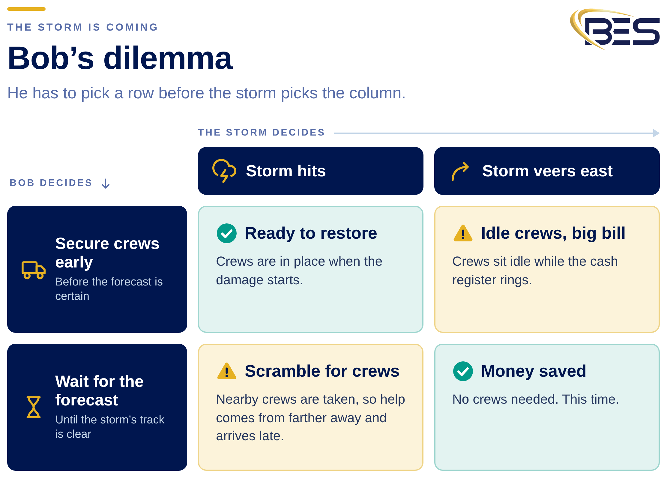
The predictions were dire. The prudent thing to do was to secure as many crews as possible from neighboring power companies, find a place for them to gather, feed them, secure the necessary materials, and then wait for the storm to hit.
But what if the nor’easter suddenly veered east?
Bob would be faced with crews hanging around with nothing to do while the company’s cash register rang loudly in his ears.
Being paranoid, Bob could already hear senior management criticizing the huge waste of money.
Or Bob could play it the other way.
He could wait to secure crews until the weather forecast became more definitive. But if the storm turned out to be as bad as predicted—or worse—he would have to scramble for crews. By then, nearby crews would either be dealing with problems at their own utilities or already secured by other power companies.
Bob would have to find crews from farther away. By the time they arrived, he could have a big mess on his hands.
Either way, Bob had to make a major decision without knowing what would happen.
Bob Would Never Survive Today
Today, weather situations are even more challenging. Wildfires, hurricanes, floods, and tornadoes can cause enormous damage to electrical infrastructure.
Bob would never have survived.
And power companies aren’t the only organizations facing power-supply challenges.
A grocery store loses power and refrigeration goes down. A company planning a big grand opening has to cancel. A wedding gets called off. A person dependent on electricity for life-support equipment can’t simply wait for the power to return. Long-term care facilities, hospitals, data centers, manufacturers, and countless other organizations depend more on reliable electricity than ever before.
We need better ways of seeing what might happen before it happens.
Fortunately, technology may finally be giving us Bob’s crystal ball.
Technology to the Rescue
We hear all the time that technology will be the death of society. AI machines will render humans useless.
I disagree.
Technology has significantly improved our lives over the years. My first car was ten years old. It was falling apart. Today, a ten-year-old car can be perfectly fine. Mobile phones have computing capabilities that would have been remarkable not very long ago.
Now, the combination of new sensor technology, cloud computing, AI, imagery and GIS could provide the crystal ball Bob was searching for.
Bob’s problem wasn't that he had no data.
He had too much fragmented data. TV weather forecasts. SCADA feeds. Multiple databases. Spreadsheets. Reports. Yellow pads filled with notes.Lots of data. Not enough intelligence to make a decision.
Good Decisions Depend on Good Data—and Rapid Analysis
The key isn't a single source of data.
It's the combination of data that allows a decision-maker to evaluate multiple scenarios and determine what is most likely to happen. GIS provides the foundation for bringing much of that information together. Nearly every one of Bob’s problems had something to do with location.
Where is the storm tracking?
Where are its possible paths?
Where is vulnerable equipment that is most likely to fail?
Where are trees likely to come down?
Where is flooding expected?
What is happening to the power systems of neighboring utilities Bob might rely on for help?
Where are available crews?
Where are the customers who absolutely cannot afford to lose power?
Where, where, where. That is why GIS is so important.
Damage Assessment Is Essential. But It's Often Too Late.
Utilities understand how to restore power after a storm, tornado, wildfire or flood hits. One of the first steps is damage assessment.
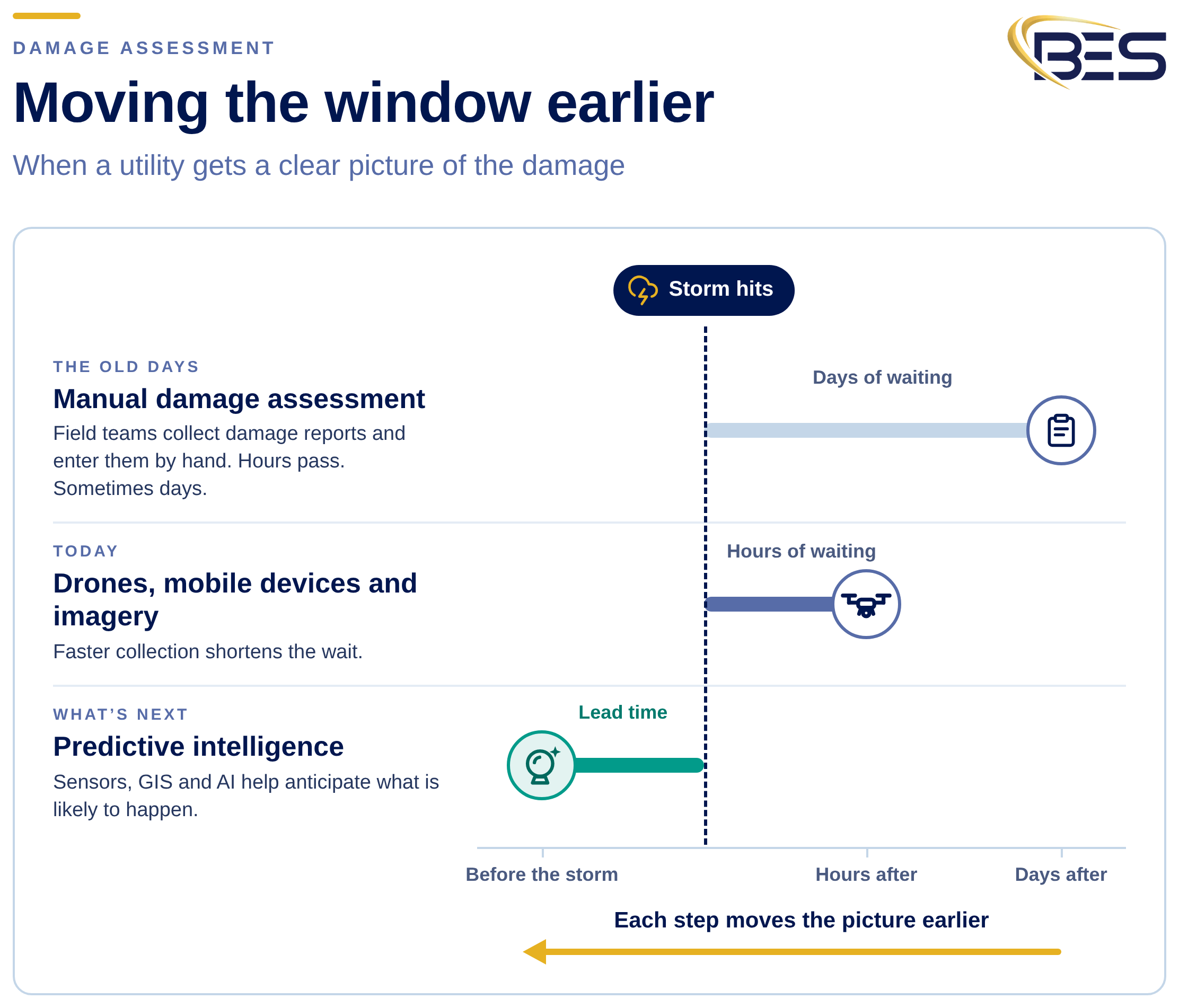
In the old days, that was a very manual process. Hordes of people raced out during and after storms to collect information about poles on the ground, transformers under water, downed conductors and equipment destroyed by fire.
After that information was collected and entered into computer systems, utilities could develop a clearer restoration picture. The problem is obvious. By the time all that information is collected, the event has already happened.
Hours have passed. Sometimes days.
Drones, mobile devices, imagery and better communications have dramatically shortened that window. That's important.
But what if we could move the window even further? What if we could improve our ability to understand what will happen?
Then paranoid people like Bob might finally get some sleep.
From Damage Assessment to Predictive Intelligence
This is where technologies such as the Ting network from Whisker Labs get interesting.
Ting sensors continuously monitor the electrical voltage waveform. They can detect electrical signatures associated with potentially dangerous conditions in a home's wiring, but the network can also provide insight into conditions associated with the utility electrical system.
One sensor provides information about one location.
A network of sensors creates something much more interesting.
Suppose Ting sensors across a neighborhood begin detecting similar abnormalities. That's very different from one Ting detecting an electrical problem in one house.
Now suppose similar patterns begin appearing across multiple neighborhoods.
And suppose we combine those observations with the electrical network model, weather forecasts, wind direction, vegetation, historical outages, SCADA information and advanced-metering data.
Suddenly we have something Bob never had.
Context.
Technology Turns Millions of Observations Into a Picture
This is where technology becomes particularly powerful. Data captured by the Ting network can be given geographic context and combined with information maintained in systems such as Esri's ArcGIS Utility Network. Clusters of Ting observations can be examined geographically and electrically.
Is the anomaly associated with a single premise? A transformer? A section of a feeder?An entire neighborhood? Or is something happening across a much larger portion of the distribution system?
The GIS provides the spatial and network context needed to make sense of those observations.
And Ting isn't the only source of information.
Utilities already have sophisticated real-time and near-real-time systems, including SCADA and advanced metering infrastructure. Add weather information, storm tracks, wind direction, vegetation, imagery, flood predictions and other sensor feeds.
Bring those datasets together in GIS and the picture becomes considerably richer.
No individual system can provide all of that intelligence by itself.
Don't Just Tell Me What Happened. Tell Me What Might Happen.
That's the real opportunity. Utilities have become very good at answering: what happened?
The next evolution is answering: what is happening?
And ultimately: what is likely to happen next?
That's where AI becomes valuable. Rather than asking Bob to stare at fifteen screens, three spreadsheets, a weather report and his yellow pad, AI can examine the combined information and run scenarios.
What happens if the storm continues on its current track? What happens if winds increase by 20 miles per hour? Which feeders are most vulnerable? Where should crews be staged? Where are mutual-aid crews likely to be available? Which customers or facilities represent the greatest consequence if power is lost?
Instead of simply giving Bob more data, give him better decisions.
Then let Bob sleep.
Building the Crystal Ball
There probably will never be a perfect crystal ball. Mother Nature has a habit of reminding us of that. But combining sensor networks, GIS, utility operational information, weather, imagery, cloud computing, and AI can dramatically improve our ability to anticipate what's coming.
That's the opportunity behind technologies from Whisker Labs (now Ting Labs), Esri, and Bent Ear Solutions.
Ting network provides a new source of electrical intelligence. Esri's GIS and ArcGIS Utility Network provide geographic and network context. Bent Ear Solutions helps bring those technologies and information sources together.
Individually, each source tells part of the story.
Together, they can help turn fragmented data into predictive intelligence.
And that might finally give utilities and people like Bob the crystal ball they've been looking for.
About the Author
Bill Meehan, PE, is an independent Executive Consultant who works with Bent Ear Solutions on selected utility engagements through WJM Electric Consulting LLC. He spent two decades in leadership at a major electric utility in the Northeast and two decades at Esri as Director of Electric Utility Solutions, and he is the author of four books on utilities and GIS.