
Deploying Real-Time Power Grid Intelligence during Winter Storm Fern
When Winter Storm Fern swept across the country, bringing widespread power outages and hazardous conditions, Emergency Operations Centers (EOCs) were under pressure to maintain visibility and coordinate resources effectively. That’s why Whisker Labs and Bent Ear Solutions agreed to make their power-outage dashboard available free of charge to all affected communities to improve decision-making and response. Using cutting-edge power outage data from Whisker Labs’ Ting Insights, Bent Ear Solutions built an interactive, geospatial dashboard in Esri’s ArcGIS that helped emergency managers understand what was happening across their communities in near-real time. As Craig Fugate underscored on LinkedIn, “ice storms break power fast, and bad information makes it worse… Making this Data public ahead of a high-impact storm is the right move.”
Turning Real-Time Data into Practical Intelligence
Whisker Labs’ electrical safety network includes over a million Ting smart sensors across the US. Built to detect electrical hazards in real time, these sensors help prevent home fires and reveal critical grid problems. When aggregated, the network provides an incredibly detailed, real-time view of power conditions across the country.
During Winter Storm Fern, Ting Insights provided real-time power interruptions and restorations at the street level, often before official reports appeared on utility dashboards. This created a powerful new layer of situational awareness for emergency managers, empowering more swift and sound decision-making.
Bent Ear Solutions used Ting Insights' high-resolution power-outage data to build a user-friendly dashboard on Esri’s ArcGIS platform. The result was a tool that allowed EOCs to see exactly where outages were occurring, how long they were lasting, and where restoration work was underway. Because it was built within a platform many agencies already use and are familiar with, many emergency managers integrated it immediately into their workflows without extra setup or training.
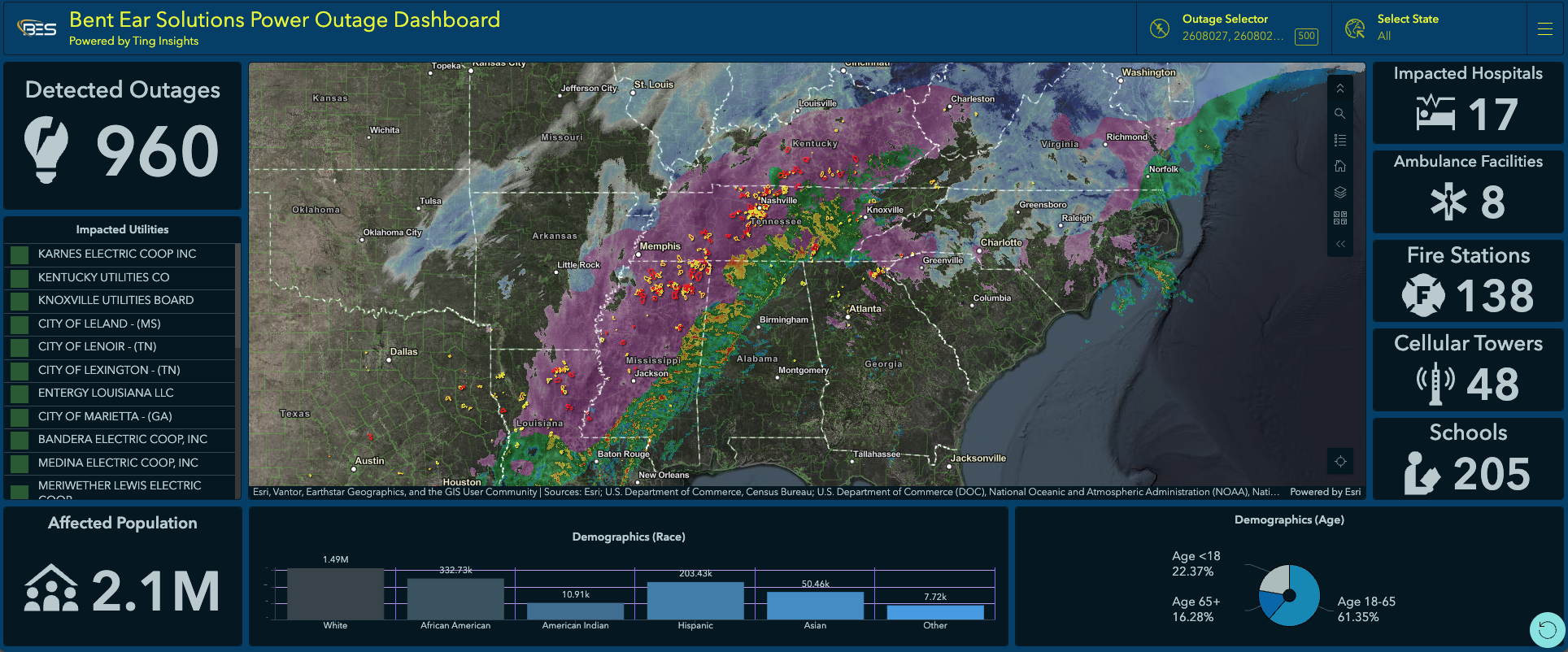
Screenshot of the public dashboard showing live the impacts of Winter Storm Fern at 11:59 AM ET, 1/25.
Helping Emergency Managers See the Full Picture
The dashboard offered EOCs several critical capabilities:
Live power status updates that refreshed every few minutes.
Neighborhood-level detail provides a much clearer view than traditional outage maps.
Overlay tools for critical infrastructure, including hospitals, cell towers, and schools.
Real-time high-fidelity weather data for instant insight on winter storm Fern.
For emergency managers responding to widespread outages, this level of visibility enabled faster, better-informed decisions. They quickly identified where vulnerable populations were losing power, prioritized critical infrastructure, and directed resources more effectively.
Real Impact for Emergency Managers
The public dashboard saw high usage among emergency managers in localities that saw significant impact from Fern, with operators sharing valuable feedback. Many said the system’s simplicity and familiar Esri interface made it easy to adopt right away. They also appreciated the precision and timeliness of the data, which offered more insight than the large regional outage zones they were used to seeing.
Several EOCs highlighted how the dashboard helped them communicate more confidently with leadership and the public. Having access to near-real-time information gave them clearer situational awareness and enabled them to explain what was happening and where resources were needed most. Additionally, smaller jurisdictions that might not have had access to advanced analytics tools benefited immediately from the free access provided during the storm.
Finally, EOCs with their own situational awareness systems appreciated the availability of Ting Insights power outage data as a web service, allowing them to, for the first time, integrate hyper-granular outage data into their GIS program. This allowed them to show how outages affected the specific areas they cared about, such as critical infrastructure, at-risk populations, and ongoing operations.
“I’ve been in enough EOCs to know this: ice storms break power fast, and bad information makes it worse.
Freezing rain plus snow isn’t just an outage issue. It turns into a life-safety problem quickly—heat, medical needs, fuel, and communications all follow.
Neighborhood-level outage data, tied to people and critical infrastructure, helps leaders make real prioritization decisions instead of guessing.
Making this data public ahead of a high-impact storm is the right move.”
Looking Ahead
The recent storm didn’t mark the end of our work; it underscored why it matters. Whisker Labs and Bent Ear Solutions remain focused on advancing real-time grid intelligence and share a continued commitment to supporting emergency managers.
Whisker Labs will continue to expand the Ting Insights data capabilities, while Bent Ear Solutions focuses on creating new ways to integrate that valuable data into the GIS platforms that emergency managers already rely on. The goal is to ensure EOCs have access to familiar, reliable, real-time information during severe weather or grid disruptions.
A Shared Vision for Resilience
The collaboration during Snowstorm Fern showed what’s possible when advanced data and practical design come together. Ting Insights power outage data provided unprecedented visibility into power grid performance, and Bent Ear Solutions turned that data into actionable information that emergency managers could use immediately to protect their communities.
As severe weather events become more frequent and complex, both teams are committed to helping emergency operations centers stay one step ahead by leveraging data, technology, and collaboration to build stronger, more resilient communities.