

Case Study of Kentucky Emergency Management: Why KYEM Replaced Its Legacy Incident Management System with KERMIT
About the Customer
Kentucky Emergency Management (KYEM) supports statewide emergency coordination across 120 counties and manages approximately 1,200–1,300 proprietary crisis management system accounts to enable situational awareness, incident management, and multi‑agency coordination.
The Challenge: Legacy Systems That Couldn’t Scale
Like many emergency management organizations, KYEM licenses an on‑premises incident management system. As operational demands grew, the platform reached its limits. During activations, it was noted that once concurrent users exceeded approximately 100–125, system performance degraded significantly.
These limitations became critical during the COVID‑19 response (2020), when KYEM supported a Public Health task force with 150–200 concurrent users. The system was unable to handle the workload, resulting in PPE and resource requests being lost or dropped. Additionally, efforts to integrate incident data into ArcGIS for visibility and reporting were unsuccessful. The legacy systems connector failed, resulting in duplicate, overwritten, and deleted records.
Bottom line: KYEM required a scalable, resilient, and interoperable solution without introducing another standalone system.
The Strategy: Maximizing Existing Investments
KYEM leadership adopted a GIS‑first strategy, recognizing ArcGIS as a shared, statewide operational language already embedded across Kentucky agencies. As KYEM IT Supervisor Doug Eades noted, this approach enabled the deployment of a common operating picture that leveraged tools KYEM’s partners already understood and trusted.
KYEM focused on operationalizing existing investments:
ArcGIS for data collection, dashboards, and situational awareness
Microsoft 365 to support workflows such as approvals, notifications, reporting, and secure information sharing
During the pandemic, this strategy was validated in practice. KYEM shifted request intake to Esri Survey123, processed requests within the ArcGIS platform, and used Power Automate to notify public health warehouses when requests were approved, improving reliability and response speed.
Hear Doug Eades from KYEM go deeper.
He's joining BES CEO Chris McIntosh for a free webinar, Getting More from the Tools You Already Own, on July 8. Seats are limited.
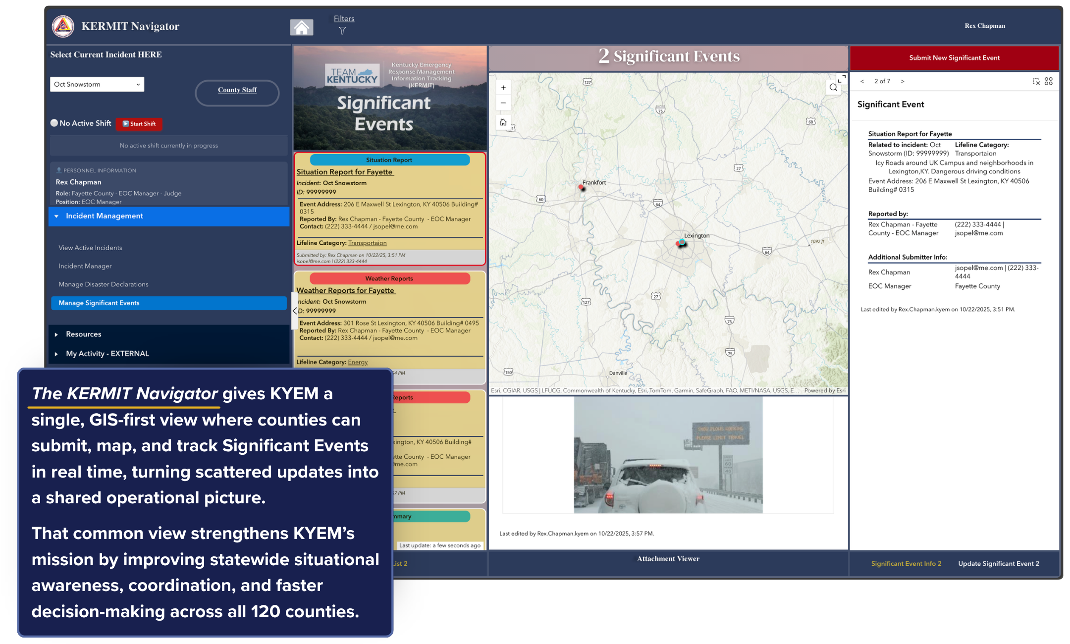
The Solution: KERMIT
This strategy has now been applied to the redesign of KYEM’s Incident Management system. This means building on the successful use of ArcGIS and Microsoft 365 during COVID and applying the approach to this new mission. KYEM formalized its modernization effort as KERMIT, a cloud‑based, ArcGIS‑driven platform designed around KYEM’s operational workflows.
A key design principle was ease of adoption and sustainment across 120 counties, where many emergency managers balance multiple roles. KYEM emphasized familiar Records Management and GIS solution patterns, dashboards, and a consistent user experience to create a “common look and feel” across both day‑to‑day (“blue sky”) and disaster response (“dark sky”) operations.
Recent advances in Esri and Microsoft interoperability further strengthened the platform, enabling capabilities that had previously been underutilized within the emergency management community. This is especially true for the often-overlooked aspects of systems, such as administration and maintenance.
How Bent Ear Solutions Supported KYEM
Bent Ear Solutions (BES), in collaboration with Esri and CDR Maguire, supported KYEM by building from its existing technology investments rather than introducing new, single‑purpose tools. As KYEM described it, Esri built the foundation, and BES helped remodel the house.
In the building of KERMIT, the BES and Kentucky Team did the following:
Operational Simplicity
KYEM emphasized the importance of systems that they could understand and manage independently. BES configured intuitive, maintainable solutions aligned to KYEM’s operational realities.
Emergency Management Fluency
BES translated emergency management workflows into practical ArcGIS configurations, including dashboards, experiences, and user onboarding, often overlooked but mission‑critical details. KYEM highlighted BES’s ability to “speak the emergency management language,” enabling rapid delivery and effective surge support during multiple state disasters in 2025.
Deep Collaboration
BES worked closely with KYEM staff across field operations, IT, and leadership to expand capabilities, streamline processes, and improve outcomes without replacing existing systems.
Outcomes and Early Wins
Although KERMIT continues to evolve, KYEM is already realizing measurable benefits:
Reliable request intake and approvals at scale using Survey123, ArcGIS, and Power Automate, ensuring continuity and traceability during major activations
Consistent user experience across functions, lowering training demands, and improving adoption
A scalable alternative to legacy constraints, reducing reliance on costly, limited crisis management licenses while improving capacity and interoperability
What’s Next
KYEM’s roadmap extends beyond incident response to support other mission areas within KYEM, such as inventory tracking, financial and grant management, training lifecycle management, and other “blue sky” operations using ArcGIS and Microsoft 365 as the foundation. This approach continues to expand KYEM’s capabilities while maintaining flexibility for future needs.
See it on the big stage.
Doug Eades presents KERMIT at Esri's Safety & Security Summit, July 12 in San Diego.
Key Takeaway
Kentucky Emergency Management’s experience demonstrates a pragmatic model for modernization: leverage and operationalize the technology you already own to support mission‑specific workflows that are easy to adopt, sustain, and evolve. Through this connected framework, KYEM has advanced toward a scalable, resilient, and cost‑effective operating model for both daily operations and emergency response.